Commlink #36
Weekly Review

This week at Community DAO marks an uptick on all levels of operation through legitimate, organic sales activities. C0MM/DAO is now more than just a Community. It is a real business! As a start-up, many things are contingent on the “growth potential” vs the “growth reality.” A seed will only germinate if certain conditions are right. Not all seeds will grow. Maybe it is a bum seed internally. Maybe it’s too cold outside. Maybe the soil is not conducive at that moment. Maybe there is not enough moisture, light, and so forth to facilitate that “magic” moment, when the seed transforms into a growing plant.
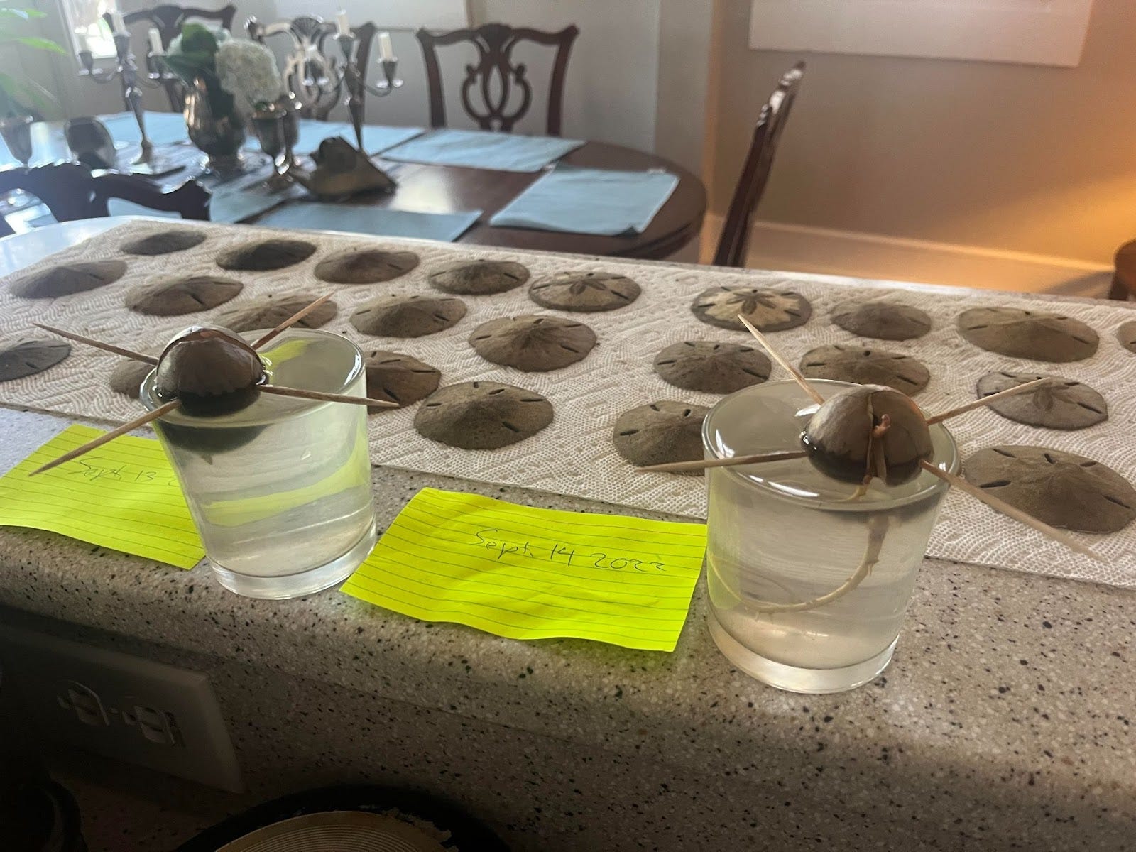
Avocado seedlings sprouting in water
But when it does happen, and that seed sprouts forth, you better continue to foster its growth closely so that you can harvest the fruits when they are ripe and mature…
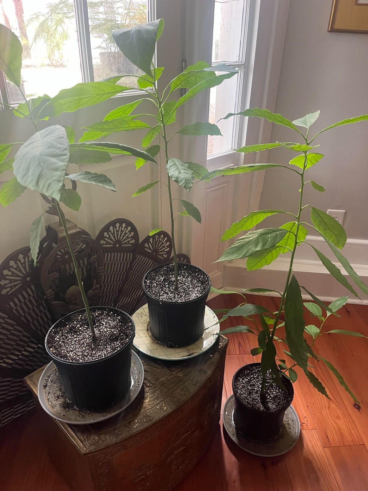
Actively growing avocado trees as young plants
Well, they are ripe and mature here at Community DAO!
And how timely that we continue this line of thinking as we are at the culmination of our Harvest/Halloween/Day of the Dead Design Theme weeks:
https://docs.google.com/document/d/1WTO1gOQxPoedTESYL9e_WjCGj1Zw0UxdeDMJr8f3JG0/edit?usp=sharing

Halloween Special Edition Cyber Raven NFTs awarded!!!
We collected 146 designs for this week’s contest here by Halloween Day, October 31st, 2022! Amazing protocol generator output again!!! Curators are still making judgments on final winners as I speak.
On the writing front, Dr. Alina Okun continues to break new ground, revolutionizing a data mining, crowdworking mechanism. We received another record 20 docs full of several hundred new features for our Listen Up Collab focused currently on anywhere in ALL of Arizona…

Alina has constructed 2 databases so far that are beginning to operate like mines. Check the original, as it grows, on Notion: https://www.notion.so/df69eac4e3654a91b0c64dbeb639d463?v=f178465872464bbfbae736ebeba7cdb3
And see her progress on a totally fresh interface as she migrates data onto Airdrop like an artist(!), which offers several advantages in handling large data sets like we are beginning to see at C0MM/DAO: https://airtable.com/shruS5Ql4g8EdhdOT/tblVdMyLtWjb5Ldn1/viwuN98Pb6iUCRAnw
As we review week 6 of this active collab with Listen Up, the partnership strengthens as our strategizing progresses further after several meetings with Rogi and Dustin. If you are curious about Listen Up, check out the website here: https://listen-up.app/
And follow up by joining their Discord here: https://discord.gg/a4WFBZZEXh
This continues to be a fruitful collaboration, and we plan to map out the entire globe with our team, eventually!
In addition to the cyber Raven NFT giveaways for designs, we are including 2 from the Raven Friend’s beloved Otter series for the most well-composed features for Listen Up from Week 36...

On the Commtower financing front, the Core Particle Ring series continues to sell in auction and on the sale floor: https://www.ravenist.com/search?q=core+particle+rings

In addition to now embedding access links and installers on the activation page of each ring, considerable concept development continues to surface on forums where these rings are sold…

In Raven Angels, this has emerged on the sales floor of Core Particle Ring #1…
Let’s take a moment to cover a discussion on governance at C0MM/DAO since this topic has also been a chief focus from Week 36, and it involves a certain level of complex thinking, needing explanation step-by-step...

Our governance token will be the C0MM/DAO and will be visualized as a white ball, in the tradition of secret balloting organizations (https://en.wikipedia.org/wiki/Blackballing). I like the idea of moving away from the token idea, as that reminds one of an arcade. All assets can be visualized distinctly. This is one of the truly awesome features of the Ravencoin system, especially with the DNS style naming/branding. But I have not minted just yet because I am curious about specific voting utilities possible. It seems that there is a unique protocol that we are able to do where voting tokens are issued like 1:1 so that they can be verifiably sent to an address while the owner still maintains his governance ball(s) in his possession. Does anyone here know how it works? If I generate the whiteball as a sub-asset, will it be able to be used for that? I am minting soon, as the way to obtain the whiteball is through the Core Particle Ring. And you don't just receive it, you have to quest for it, to the Commtower. See available Particle Rings…
Also, there is the issue of “blackballing.” Some have asked how that will work, in various forums…
Basically, the way blackballing will work is that there are only a few blackballs. Currently, I see the necessity for 3, possibly 4. There are 2 basic bodies of governance in the DAO as I conceive it. It is a bicameral arrangement, similar to the way representative govts in the West have been forming for centuries, with a Senate and a House of Reps, in the US, for example. 1 is based on Numerical voting power, like the house of reps, and is symbolized by holders of the C0MM/DAO white balls. In this house, a whale or whales may start scooping as many up as they can afford and gaining preponderance on voting measures, just like California can come to sway American politics by having so many people living there. But how do we prevent that component from the 51% takeover that has plagued DAOs on ETH and other governments subject to the tyranny of the majority? By requiring the other House to be in concurrence before key measures are passed.

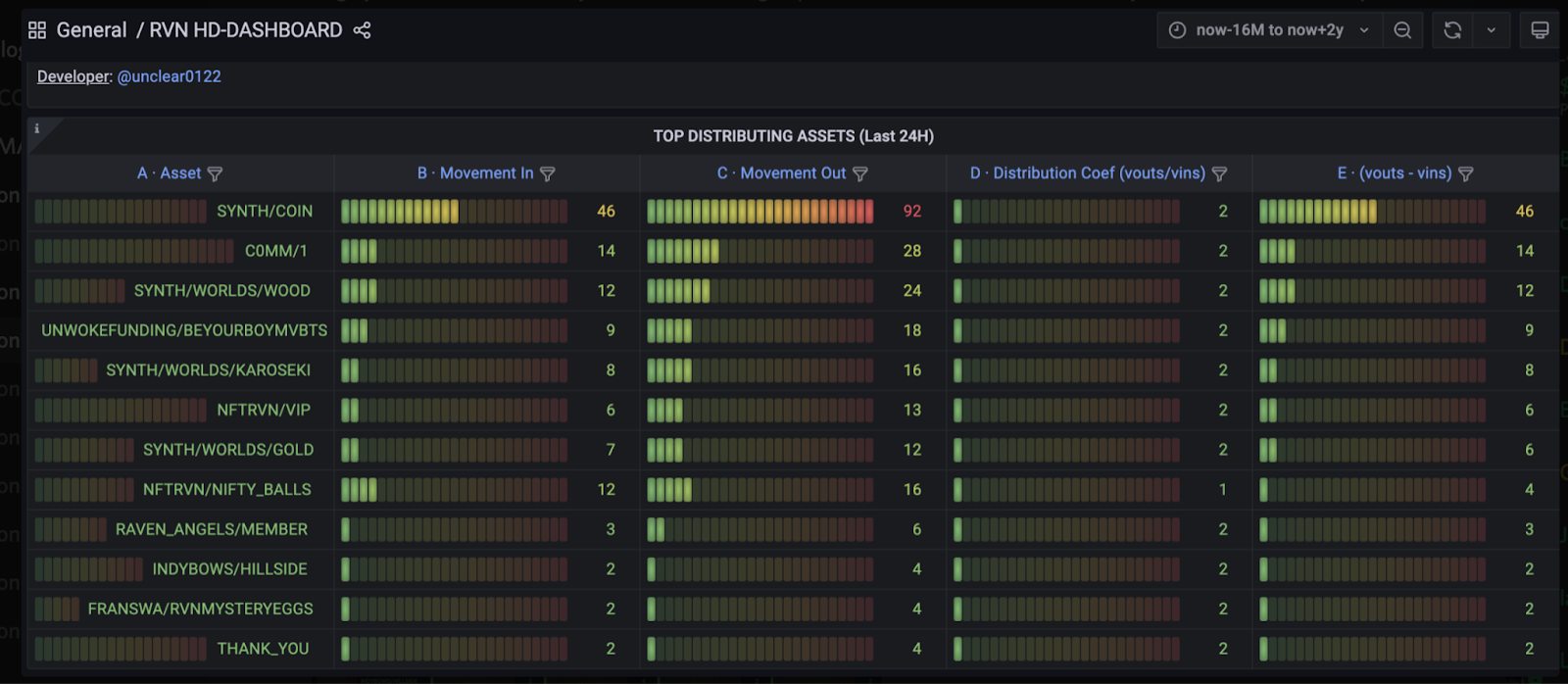
What is that other house? The other house is the "Triumvirate" of Foundation/Marketing/Research at C0MM/DAO, which would reflect the equality of diversity of interest, like the Senate in the US. This enables Rhode Island to have an equal voice on one level as California since both can only send 2 people to the Senate. In our case, the Triumvirate represents our most active core of meritorious contributors, basically all of our curators in their various fields of expertise, and then the content creators and members of our discord who have begun earning the C0MM/1. We have 160 holders of this token so far, and it consistently bounces up to the top 5 active distributing assets on the RVN chain each week.
So, the heads of each one of these sectors have a black ball. And we will probably install Jeff Lippert, CGO of Alterverse and early co-founder of C0MM/DAO as a key player holding keys to Sky City with one. And if any one of these holders throws a black ball, a measure is killed no matter how many white balls have voted from the other house. But normally, they would not want to do this in a general vote, except in an extreme case of a conflict of interests or to prevent some sort of malfeasance, because they are so invested in the organization with time and energy, that they want the system to flow for the most part unhindered through basic majority voting motions. Most of the time, white balls only will be cast, and the motion has the most, will carry. All I can say on that for now....Later, we can continue the discussion. Not sure if this is even the best place for it. But I think it is an important discussion, and I am glad you have raised these questions. ETH developers have not really studied the theory of the Concurrent Majority as it has developed in the American system, though it has largely been derailed irl. But you have to have a grasp of it in order to construct a solid system that will eventually verge on automation of its own accord.
Also, it may be wise not to completely kill a measure that has been blackballed but to require a subsequent vote scoring a higher percentage than 51%, like 75 or 80%. This is how vetoes can be overridden in the US. Was also how the theory of Nullification was originally designed to work. If a state nullified an action of the Federal govt, it would necessitate the requirement of a higher % of "yeas" than normal, bringing into play more of the surrounding community by threatening to stop the forward action of the government on a motion, if more voices did not arrive and be heard in time. The fine details of the situation are still being "tuned" as we are just getting to this stage of development after months of building the infrastructure of the org on other fronts.
Some of my recent thoughts and posts on how the Decentralization movement spreading across the globe connect ancient political myth, theory, and Tradition, with modern technology and contemporary US political strategies aligned with early Jeffersonian themes…
"1 will corrupt...2 will divide...With 3, there is balance."
- Galadriel and Celebrimbor on the necessity of dividing power into 3 channels...
To divide the initial governance of a #DAO into 3 channels is decentralization enshrined in ancient political theory.


Ravencoin, in the context of the historic US decentralization movement, is a top candidate for achieving full decentralization in all markets and economic and political fields, next to, or on top of Bitcoin’s leading the charge since ‘09.
A recent article by Tron Black, lead Ravencoin Developer: "I’m not a political animal. I lean libertarian (not the party, but the ideas), and would like less government interference in well…just about everything."


I have long believed that the plan of the original founding genius of the American constitution, Thomas Jefferson, was to build a system that basically was a DAO, in that it contained all of the right features to channel power safely, and effectively, and eventually, like an automatic machine, more or less. But for a variety of reasons and historical circumstances, war, plotting, and fortune's nature, that version of an early DAO was diverted from achieving its goal by the forces of centralization. But, obviously, it is an ongoing debate, and the country could, in the end, still achieve that destiny, though we can do it first thru Ravencoin, building a new international federation, with the core principles of decentralization inscribed into the heart of the whole blockchain!
Anyhow, that is enough reporting, reviewing, and theorizing from me for another week. Please enjoy the rest of the show! Again, a new issue of Commlink has emerged as our largest edition yet! We present to you the gatherings of Week 36….
Happy Halloween!!!
Best,
Dow
Stats
Twitter Followers: 1,352
Discord Members: 477


Weavers Needle
Weavers Needle is a prominent peak formed by a rock pillar that rises to a height of 1,000 feet. Weavers Needle is an erosional remnant with a summit elevation of 4,555 feet located in the Superstition Mountains east of Phoenix, Arizona. The spire was formed when a thick layer of tuff (fused volcanic ash)—a volcanic plug—was significantly eroded (1,388 m). Large Saguaro cacti dominate the desert environment, along with other cacti and mesquite bushes. Pauline Weaver, a well-known mountaineer, inspired the peak's naming.
For many years, Weavers Needle has been an integral part of the legends surrounding the Lost Dutchman's Gold Mine. Many treasure hunters have looked in the area where the Needle casts its shadow since legend has it that there is a large gold vein there. Hundreds, if not thousands, of people have gone on a gold rush around Weavers Needle. Weavers Needle appears to have two distinct peaks due to a big crack running along its side. One must approach this from the side.
Circlestone
Circlestone is perched atop one of the Superstition Mountains' tallest peaks. To the southwest of Circlestone is Mound Mountain, the highest point in the Superstitions at 6,266 feet. Impressive vistas can be had from the ruins. Superstition Mountain may be seen to the west, and its profile is easily recognizable to anyone living in the Valley of the Sun. The Four Peaks of the Mazatzal Mountains are located to the north. The Sierra Ancha mountains can be seen to the northeast, with the Mogollon Rim in the distance. Mount Graham is seen in the distance to the southeast, while the mining region of Globe is visible to the east. If the Native Americans who constructed Circlestone intended to use it for religious ceremonies, they certainly chose a spectacular location.
There is no mistaking the fact that the stones in this ruin form a big circle. From the hub of the circle, two stone piles extend in a radial fashion.
Vulture Mine
In Maricopa County, Arizona, in the United States, there was a hamlet known as the Vulture Mine, which was also a gold mine. The mining operation began in 1863 and eventually became the most profitable gold mine in the history of Arizona. The mine yielded a total of 340,000 ounces of gold and 260,000 ounces of silver between the years 1863 and 1942. Throughout the course of its history, the mine was responsible for the migration of more than 5,000 people to the region and the establishment of the city of Wickenburg in the state of Arizona. Vulture City was the name of the settlement that sprang up around the mine.
Granite Reef Diversion Dam
Granite Reef Diversion Dam is a cement diverting dam 22 miles northeast of Phoenix, Arizona. It dams the Salt River to provide irrigation.
The dam disconnects nearly all of the Salt River's water into the Arizona and South Canals, which supply irrigation and drinkable water to Phoenix. Except when there is regular and strong upstream precipitation, the Salt River below Granite Reef is normally dry. When the lakes upstream are full, minimal to moderate releases are made via floodgates at each end of the dam. The dam is meant to be breached by large discharges that occur every 10 to 40 years.
The length of the dam is 1,128 feet, and its height is 29 feet. Its volume is 35,000 cubic yards.
The dam was erected between 1906 and 1908 by the United States Bureau of Reclamation to replace the Arizona Dam, which was washed out in 1905. The Salt River Project, an electric cooperative, runs it.
Palo Verde Generating Station
The Palo Verde Generating Station is a nuclear power plant in western Arizona near Tonopah. It is 45 miles (72 kilometers) west of downtown Phoenix, Arizona, and is near the Gila River, which is dry except for the rainy season in late summer.
The Palo Verde Generating Station is the greatest power station in the United States in terms of net generation as of 2013. Its average electric power generation is around 3.3 gigatonnes (GW), and it serves approximately four million people. The facility is operated and owned by the Arizona Public Service Company (APS). The Salt River Project (17.5%), El Paso Electric Company (15.8%), Southern California Edison (15.8%), PNM Resources (10.2%), the Southern California Public Power Authority (5.9%), and the Los Angeles Department of Water and Power (5.7%) are its other main shareholders.
The Palo Verde Generating Station, located in the Arizona desert, is the world's only big nuclear power station that is not near a large body of water. To cool the steam produced by the power plant, water from treated sewage from numerous adjacent cities and villages is evaporated.
WaterDance Plaza
WaterDance Plaza, an outdoor plaza with a $6 million dancing water attraction modeled after Bellagio, blends water effects with music and visuals.
Los Lobos, Eli Young Band, The Chainsmokers, and other artists have performed at WaterDance Plaza as part of the Super Music Series. The venue has also hosted events like the Fiesta Bowl, the College Football Playoff, Westgate Fireworks Fest, Super Bowl XLII, and Super Bowl XLIX.
In the center of Glendale, Arizona's entertainment district. This outdoor location can hold thousands of people in a distinctive setting situated between dining establishments, multiple upscale media boards, a cutting-edge, 30-by-50-foot LED board, and Gila River Arena.
St. Mary's Basilica
The Church of the Immaculate Conception of the Blessed Virgin, also known as St. Mary's Basilica, is the oldest Catholic parish in Phoenix. Up until 1924, it was the only Catholic parish in Phoenix. It has a special place in the Diocese of Phoenix's and the Church's history. Pope Saint John Paul II formally declared the Church of the Immaculate Conception of the Blessed Virgin Mary a Minor Basilica on September 2, 1985. At that time, St. Mary's was elevated to the status of 32nd basilica in the nation for historical, cultural, artistic, and spiritual reasons. On September 14, 1987, Pope Saint John Paul II paid a visit to St. Mary's while on his American visit. He knelt in the middle aisle for prayer before addressing the crowd from the balcony. The Franciscan friars of the Province of Saint Barbara have a parish at St. Mary's Basilica. In 1539, the first Franciscan arrived in the region.
Temple Beth Israel
Temple Beth Israel, Phoenix's first Jewish synagogue, was established in 1921 and served as both a synagogue and a community center. When the Beth Israel congregation outgrew the structure, it was sold to the Southern Baptist Convention in 1949. It later became Phoenix's first Chinese-language Christian church. The First Chinese Baptist Church sold the building to Iglesia Bautista Central, a Mexican Baptist Church, in 1981.
The Arizona Jewish Historical Society's Cutler-Plotkin Jewish Heritage Center, which routinely conducts faith- and community-related activities and events, now occupies the oldest Jewish structure in central Phoenix. Visitors can also tour the historic structure and spend time in the museum gallery, which houses artwork and displays. The structure will be 100 years old in 2021.
Historic Tanner Chapel AME Church
The oldest African-American church in Arizona is the historic Tanner Chapel African Methodist Episcopal Church. The original building was constructed during the pioneer era (1886, according to courthouse records). With the acquisition of more property in 1899, the African Methodist Episcopal Mission was renamed in honor of Bishop Benjamin T. Tanner as Tanner Chapel African Methodist Episcopal Church. In later years, the property was sold and the current site was acquired. The present-day Tanner Chapel was completed in 1929.
During a visit to Phoenix on 3 June 1964, Martin Luther King Jr. spoke in front of the church. According to the records of Arizona State University, King spoke for around six minutes and described the fight for racial justice as a "war to defend the soul of America." Nine months had passed since his legendary "I Have a Dream" address at the March on Washington prior to his brief remarks. King told the congregation at Tanner, "People of goodwill throughout the nation must come to view racial injustice as wrong, and they must not rest until it is eliminated from every aspect of our society."
The Phoenix City Council approved the church as a historic landmark with both standard and landmark historic classifications on December 15, 2010.
First Christian Church in Phoenix
The president of Southwest Christian Seminary in Phoenix commissioned Frank Lloyd Wright to construct a Classical University in 1949. Wright's finished plans revealed his concept for an 80-acre campus in 1950, complete with a chapel, administration buildings, seminar rooms, library, Greek theatre, and faculty housing. The seminary, nevertheless, discontinued operations before the campus could be erected.
The First Christian Church approached Wright's widow, Olgivanna, in the early 1970s, and she granted them permission to borrow Wright's triangle chapel design. The chapel's roof and spire climb seventy-seven feet, supported by 23 slender triangular pillars, to recall the Holy Trinity and represent a prayerful attitude. The stained-glass insets in the spire cast light onto the floor of the 1,000-seat diamond-shaped sanctuary. Taliesin Architects performed the sole changes to the original plan, which were the installation of the baptistery and choir loft, as well as the administrative wing.
Chapel of the Holy Cross
This chapel, perched high above Sedona's red rocks on Coconino National Forest land, was designed and built by local rancher and sculptor Marguerite Brunswig Staude. Staude received assistance from the late Senator Barry Goldwater in acquiring a special-use permit, and Fred Coukos oversaw the $300,000 chapel's construction over the course of 18 months.
In addition to being a work of beauty in and of itself, the chapel is renowned for the artwork found both within and at the nearby gift shop.
Elvis Presley Memorial Chapel
This church, which was initially constructed as a movie prop for the 1969 Elvis Presley Western Charro!, is also known as the Elvis Chapel. It was constructed at Apacheland Movie Ranch, which was a well-known film set and attraction in the past. Sue and Ed Birmingham gave the chapel to the Superstition Mountain Museum after it had been through two devastating fires: one in 1969 and one in 2004, the latter of which completely destroyed the ranch. In order to give the chapel, it had to be disassembled, transferred, and then reassembled.
This chapel is a popular tourist destination and wedding location, despite the fact that it has never been used to house a congregation of its own.
Maha Ganapati Temple of Arizona
The Maha Ganapati Temple of Arizona, founded as a charity in 2000, is the state's largest Hindu temple. The edifice, built in genuine Agamic style, has shrines to over a dozen presiding deities as well as interior and exterior sculptures, including four beautifully sculpted vimanas (towers). The temple is also a part of the Harvard University Pluralism Project, which is dedicated to cataloging all religious entities in the United States.
San Xavier del Bac Mission
San Xavier Mission, founded as a Catholic mission by Father Eusebio Kino in 1692 and now a National Historic Landmark, is the oldest European edifice still standing in Arizona.
The existing structure of this church was built in the late 1700s, when Southern Arizona was still a part of New Spain. Fr. Juan Bautista Velderrain, a Franciscan missionary, borrowed money from a Sonoran rancher in 1783 to begin building the current church. He commissioned the services of architect Ignacio Gaona and a sizable O'odham labor force to build the current structure.
Because of Mexico's independence in 1821, San Xavier eventually joined the Mexican nation. In 1837, the century's final resident Franciscan left. The Gadsden Purchase in 1854 brought the Mission under U.S. jurisdiction. The Diocese of Santa Fe claimed San Xavier as its own in 1859. Once again, regular services were held in the Mission once Tucson was established as a diocese in 1866.
Old Adobe Mission
Old Adobe Mission, formerly Our Lady of Perpetual Help Catholic Church, was hand-built by Mexican immigrants who arrived in Scottsdale in the late 1910s. This was Scottsdale's first Catholic parish when it opened in 1933. It has stunning Spanish Colonial Revival architecture and handcrafted stained-glass windows designed by Robert T. Evans. It became a parish in 1949 and served the community until 1956, when the parish outgrew the building and relocated to a larger church.
It is now a historic landmark, as well as the oldest standing church in Scottsdale and one of just three adobe structures in downtown Scottsdale. The mission hosts a number of annual events, including Dia de los Muertos and a live nativity scene. It offers a one-of-a-kind location for historical study and spiritual isolation to those who visit.
Lost Dog Wash Hiking Trail
Lost Dog Wash is an ancient jeep tour route that winds its way into the McDowell Mountains by climbing a low ridge. This renowned hiking trail in Scottsdale provides hikers with breathtaking panoramas of the surrounding landscape, including famous sites such as Frank Lloyd Wright's Taliesin West and other mountains such as Camelback and Pinnacle Peak. The trail only climbs around 380 feet in height over the course of its entirety, but because it is an out-and-back trail that is just over 5 miles long, it is considered to be of intermediate difficulty.
Go John Trail
Cave Creek Regional Park covers an area of 2,922 acres and is located in the community of Cave Creek, which is located just to the north of Phoenix. The Go John Trail is located within the park. The first 5.9 miles of the loop are lengthy switchbacks that take hikers past desert plants and enormous saguaro cacti. You will be rewarded with vistas of downtown Phoenix as well as the Hieroglyphic Mountains after walking approximately one mile in. The track can be hiked at any time of the year, but the best time to go is in the spring, when the desert's flora is at its most vibrant and colorful.
TPC Scottsdale - The Stadium Course
The Stadium Course at TPC Scottsdale was specifically created to host the PGA Tour's Phoenix Open, and it has done so since 1987. It was designed by Jay Morrish and Tom Weiskopf. The course was built with great drama in mind, and it is highly renowned as one of the most exhilarating and spectator-friendly in all of golf. It also features an explosive final stretch that starts with the risk-reward 15th hole. From the tournament tees, the course measures more than 7,200 yards, yet players who visit Arizona and play the course will discover that it has more forgiving fairways than many other desert courses in the region. The TPC experience offers one of the largest practice facilities in the area, as well as a lavish clubhouse with the Toro Restaurant and Rum Bar. The Champions Course, which operates out of an adjacent facility, is also a part of TPC Scottsdale.

The Refrigeration School, Inc
The Refrigeration School, Inc. prepares students for careers in the HVACR and refrigeration industries. The organization offers graduate programs in electro-mechanical technology, mechanical maintenance engineering, refrigeration technologies, welding, and solar power and technology. Additionally, it helps graduates seek financial aid. The business was founded in 1965. The Refrigeration School prepares individuals for entry-level positions in heating, ventilation, air conditioning, and refrigeration. RSI is a trade school in Phoenix, Arizona that offers HVAC, refrigeration, electrical, and welding training programs. Students receive practical training that equips them with the skills necessary to find employment in their field following graduation.

Sahuaro Ranch Foreman’s House
This house was the last to be built at Sahuaro Ranch, sometime around the turn of the twentieth century. Little is known about who lived in the house, but it appears to have been built as a residence for the ranch's first owner, William Bartlett. It replaced a much older structure known as the "Men's Quarters" by Bartlett, which was a simple one-story adobe structure dating from the ranch's early years.
The wood-frame section was added soon after this house was built to serve as a kitchen. Later, the house was modified further, transforming it from a simple bunkhouse into a home suitable for the ranch foreman and his family. On the first floor, a bathroom was added, the porch was enclosed, and a carport was attached to the north wall of the addition.
The City of Glendale restored the Main House, Fruit Packing Shed, Foreman's House, and other historical structures from 1995 to 1996. The Main House is now open for tours, and the Foreman's House houses the park staff who oversee operations at Sahuaro Ranch.
Forney House
The Forney House, built in 1893, is Glendale, Arizona's second oldest house ever lived in time of historical dates. The Adobe house in Sahuaro Ranch is Glendale's oldest structure. The Glendale Historical Society has designated the house as a historical landmark. This property is in Glendale's Floralcroft Historic District, which is on the National Register of Historic Places.
The Forney house is made of red brick that has been painted. Little is known about the residence, but it remains a private residence to this day.
Jonas McNair House
The Historic (NRHP) Jonas McNair House, located at 5919 W. Myrtle Avenue in Glendale, Arizona, was built in 1897. In 1894, Jonas McNair arrived in Glendale as part of the second wave of colonists. In collaboration with another settler, he opened a butcher shop and meat market.
According to the Glendale Historical Society, the Jonas McNair House is a wood-framed Folk Victorian cottage with a "gable front and wing" form. The house was originally three rooms, but a rear addition was added in 1929.
In Glendale, McNair ran a butcher shop and meat market. His house is a rare surviving example of city-wide nineteenth-century architecture.
E.C. Bunch House
E.C. Bunch was an early Glendale settler and the original owner of this house. He was a Glendale Justice of the Peace and an educator and teacher.
Historians describe the home as a single-level Cottage built in the Victorian folk-style of architecture, located at 5602 W. Lamar Road, just south of the city's historic central business district.
While the neighborhoods to the north of Glendale Avenue, such as the National Register-listed Glendale Townsite/Catlin Court Historic District and the Floralcroft Historic District, have maintained a high level of integrity, the neighborhoods to the south, inhabited by less-affluent residents, have seen many alterations to individual homes as well as new development. Within the context of this neighborhood, the Bunch House is a rare intact historical home.
C.H. Tinker House
Cullin H. Tinker, a prominent banker and mayor from 1916 to 1922, built and remodeled the house in 1913. J. R. Kibbey designed the house as a comparatively small Neo-Classical Revival bungalow.
The C H. Tinker house, 6838 N. 59th Drive, is a two-bedroom Neoclassical-style residence on the west edge of Glendale's central business district. J.R. Kibbey of the renowned local architectural firm Lescher and Kibbey designed the house. The structure is now used as a wedding venue.
Alph and Dorothy May Jorgenson bought the house in 1936. Military personnel and defense plant workers referred to the residence as the "Jorgenson Apartments." Following the war, John and Virginia Hook bought the house and lived there for nearly 50 years. Scott and Natalie Stahl bought the house from the Hooks in 1997. They have lovingly restored it to its 1919 appearance since then.
Hine Building
In 1913, Alice S. Hine, an agent for the Phoenix Title and Trust Company, hired Home Builders Company to build the two-story masonry structure. Mrs. Hine added a substantial addition to the building along 58th Avenue in 1919. The city has designated it as a landmark with a plaque. It is now home to a variety of businesses.
Julio Sancet House (The Hickman House)
The Julio Sancet House (also known as The Hickman House) was constructed in 1919 and can be found at 7158 North 57th Avenue in Glendale, Arizona. From 1919 to the 1930s, it was the home of Julio Sancet, a local rancher. The Julio Sancet House is an excellent example of a well-detailed, low-key bungalow. It represents the type of development that occurred in the Glendale townsite in the mid-1920s and contributes to the district's predominant bungalow character.
On June 9, 1992, the Glendale Townsite Catlin Court Historic District was added to the National Register of Historic Places.
Robert W. Cole Building
The Robert W. Cole building is located in Maricopa County, Arizona, in Glendale. It's on North 58th Avenue, just north of West Glendale Avenue, on the right as you head north.
In 1919, Robert W. Cole purchased three downtown lots. J. C. Howell, a local architect, was hired to design the two-story structure, and Robert Fultz was the builder. Construction began in June 1919 and was completed in September 1919, when Cole opened a general store.
The building housed a Sprouse-Reitz 5 & 10 Cent Store in the 1940s. The city has designated the building as a landmark with a plaque.
Winona Site
The Winona Site is a collection of archaeological sites located in Coconino County, Arizona, within the Coconino National Forest. It's nearby Sunset Crater, which erupted in 1066. This site contains evidence of cultural changes that occurred as a result of the eruption. In 1964, it was designated a National Historic Landmark.
John McGregor, an archaeologist affiliated with the Museum of Northern Arizona, conducted the first formal investigation of the Winona Site in the 1940s.
McGregor excavated six pit houses with architectural features typical of the Hohokam people of the 10th century. He hypothesized that the Hohokam, who are typically found further south, were drawn to this area by the fertility of the landscape created by the crater's eruptions. In addition to the pit houses, McGregor discovered trash mounds and a ball court. Pottery discovered at the site was also Hohokam in color, decoration, and design.
Ventana Cave
Ventana Cave is a Southern Arizona archaeological site in the Tohono O'odham Indian Reservation. Under Emil Haury's direction, teams led by Julian Hayden excavated the cave in 1942, and a team led by Wilfrid C Bailey, one of Emil Haury's graduate students, excavated it in 1941. Ventana Cave's deepest artifacts were recovered from a layer of volcanic debris that also contained Pleistocene horses, Burden's pronghorn, tapir, sloth, and other extinct and modern species.
The Ventana Complex was named after a projectile point found in the volcanic debris layer that was compared to the Folsom Tradition and then to the Clovis culture. Radiocarbon dates from the volcanic debris layer revealed an approximate age of 11,300 years ago.
Tumacácori National Historical Park
Tumacácori National Historical Park is located in Santa Cruz County, southern Arizona, in the upper Santa Cruz River Valley. The park spans 360 acres (1.5 km2) and is divided into three sections. The park safeguards the ruins of three Spanish mission communities, two of which are designated as National Historic Landmarks. It also houses the National Historic Landmark Tumacácori Museum, which was built in 1937.
The first Spanish Colonial Jesuit missions in the area were established in 1691, and the two oldest missions in southern Arizona are Mission San Cayetano de Tumacácori (at Tumacácori) and Mission Los Santos ngeles de Guevavi. The Franciscan church of Mission San José de Tumacácori was built in the 1750s, across the river from and replacing Mission San Cayetano de Tumacácori. The third mission, Mission San Cayetano de Calabazas, was founded in 1756.
The Tombstone Historic District
The Tombstone Historic District is a historic district in Tombstone, Arizona, notable for its connection to the conflict between lawlessness and civilization in frontier towns of the wild west, as well as its history as a boom-and-bust mining center. The iconic O.K. Corral is located within the historic district and is related to the Tombstone famous Gunfight at the O.K. Corral, which occurred on Fremont Street, near the back entrance of the O.K. Corral, on October 26, 1881. In 1961, the district was named a National Historic Landmark.
When it was officially declared in 1961, the Tombstone Historic District had ill-defined boundaries. The landmarked area was generally accepted to encompass at least the area defined by Toughnut, Fremont, 3rd, and 6th Streets, but its exact boundaries remained a source of contention until at least 1986. The district encompasses approximately 42 acres (17 ha) of downtown Tombstone and is anchored at its southwestern corner by the former Cochise County Courthouse, which is now Tombstone Courthouse State Historic Park.
Snaketown
The Hohokam Pima National Monument is an ancient Hohokam hamlet inside the Gila River Indian Community near present-day Sacaton, Arizona. The archaeological site Snaketown, located 30 miles southeast of Phoenix, Arizona, was declared a National Historic Landmark in 1964. In 1972, the area was designated a national monument, and it was added to the National Register of Historic Places in 1974.
The Gila River Indian Community owns the land and has decided not to release it to the public. The Hohokam Pima National Monument is not open to the public. Snaketown items can be found in the museum of the neighboring Casa Grande Ruins National Monument in Coolidge, Arizona. Exhibits on tribal history and archaeology are also available at the Huhugam Heritage Center. Although definitive dates are unknown, the site was assumed to have been inhabited between 300 BCE and 1200 CE. Hohokam is an O'odham word that means "those who have passed on." It is debatable who the Hohokam people were and when the place was occupied.
Sierra Bonita Ranch
The Sierra Bonita Ranch, founded in 1872 by Henry C. Hooker, is one of the country's oldest cattle ranches, and the ranch structures have been declared a National Historic Landmark. It was Arizona's first permanent American cattle ranch. Hooker purchased surrounding ranches until his business grew to be Arizona's largest, covering 800 square miles, or nearly 30 by 27 miles. It's in Sulphur Springs Valley, about 27 miles north of Willcox, Arizona. Jesse Hooker Davis, the sixth generation to live and work on the ranch, owns the present ranch, which is much smaller but still operating.
Mission San Xavier del Bac
Mission San Xavier del Bac is a historic Spanish Catholic mission in the Tohono O'odham Nation San Xavier Indian Reservation about 10 miles (16 km) south of downtown Tucson, Arizona. Padre Eusebio Kino established the mission in 1692 in the heart of a centuries-old Sobaipuri O'odham community, a branch of the Akimel or River O'odham located along the Santa Cruz River. Francis Xavier, a Christian missionary and co-founder of the Society of Jesus (Jesuit Order) in Europe, inspired the mission's name. The first church was constructed north of the current Franciscan church. This northern chapel or church supported the mission until it was destroyed in 1770 during an Apache raid.
Mission San Cayetano de Calabazas
Mission San Cayetano de Calabazas, popularly known as Calabasas, is a Sonoran Desert Spanish Mission near Tumacacori, Arizona, in the United States. Cajetan, an Italian saint, inspired the mission's name.
Tumacacori Mission, the first San Cayetano mission. Father Eusebio Kino founded San Cayetano del Tumacácori in 1691 on his first major exploratory voyage into the Pimeria Alta. The first San Cayetano mission was destroyed during the O'odham revolt of 1751. In 1756, Spanish Jesuit missionary Father Francisco Xavier Pauer established a second San Cayetano mission to the south of the first mission on the Santa Cruz River, upstream from its junction with Sonoita Creek. He transported at least 78 O'odham from their town of Toacuquita along the Santa Cruz River to the new site on the bluffs above it to the east.
San Bernardino Ranch
San Bernardino Ranch is a historic ranch home in extreme southeast Cochise County, Arizona, near the San Bernardino National Wildlife Refuge. It is notable because of its connection to the beginnings of cattle ranching in southern Arizona and northern Mexico. The ranchland and valley are located in the Yaqui River's headwaters region.
The ranch is also known as the Slaughter Ranch since it was home to Old West lawman John Horton Slaughter from the 1880s until his death in 1922. During the Border War in 1911, a United States Army outpost called Camp San Bernardino Property, or the Slaughter Ranch Outpost, was erected on the ranch. Because of its connection to Slaughter, the site was designated a National Historic Landmark in 1964. The ranch house, washhouse, icehouse, granary, and commissary have all been preserved. Much of it has been converted into a museum called the Johnson Historical Museum of the Southwest.
Sage Memorial Hospital School of Nursing
On January 16, 2009, Sage Memorial Hospital School of Nursing in Ganado, Arizona, was declared a United States National Historic Landmark. It was the first authorized nursing school for American Indian women in the United States.
Dr. Clarence Salsbury, who came to Ganado's mission in the 1920s, was the inspiration for the hospital. He began fundraising for a larger hospital after finding the mission's small medical facility unsatisfactory. Sage Memorial, named for New York philanthropist Olivia Sage, opened in 1930 with 75 beds, a surgical unit, an X-ray department, and other modern amenities. The hospital quickly established a groundbreaking nursing school for native women. Many white people did not believe that Indigenous women could complete a nursing education at the time, but Salsbury had a different opinion. Years later, in the August 1948 issue of Arizona Highways, he praised the "high order of native knowledge, courage, and adaptability" that had aided Arizona's tribes in their survival and growth.
The Point of Pines Sites
The Point of Pines Sites are a collection of archaeological sites on the San Carlos Apache Indian Reservation in Arizona, United States. Point of Pines is a place in the San Carlos Reservation's eastern interior, occupying a high plain surrounded by the Nantack Ridge and the Willow Mountains. The Nantack Ridge is a profoundly bent escarpment with considerable evidence of prehistoric occupancy over an extended period of time. Because of the abundance of archaeological material, it is also an ideal location for continuing studies initiated by the University of Arizona at Kinishba and Forestdale. For the majority of its early history, the sites in the area fit the Mogollon Culture model outlined by Haury and others. In 1964, the site was designated as a National Historic Landmark.
Phelps Dodge General Office Building
The Bisbee Mining and Historical Museum, located at 5 Copper Queen Plaza in Bisbee, Arizona, is a local history museum. It is housed in the Phelps Dodge General Office Building, which is a National Historic Landmark due to the significance of the Phelps Dodge Corporation in the growth and development of the American Southwest. The museum focuses on local history, specifically the town's founding and rise as a mining center.
From 1896 through 1961, the building housed the Phelps Dodge mining company's headquarters. It then housed county offices and operated as the local post office before being converted into a museum by the city in 1971. It was named a National Historic Landmark in 1983 for its association with Phelps Dodge, whose development paralleled that of the country and region in the second half of the nineteenth century.
Painted Desert Inn
The Painted Desert Inn is a historic property in Apache County, Arizona, near Petrified Forest National Park. It lies off Interstate 40 and near the original path of historic US Route 66, with views of the Painted Desert.
The Painted Desert Inn's main building was completely renovated and restored throughout the years, reopening as a museum and bookstore full-time in the 1990s. The facility underwent considerable repair from 2004 to 2006 before reopening as a museum. The inn no longer offers overnight rooms (it hasn't since 1947), but it does have a retro ice cream parlor during the summer months.
Painted Desert Community Complex Historic District
One Park Rd., Petrified Forest National Park, Arizona, is home to the Painted Desert Community Complex. It serves as the administrative hub for Petrified Forest National Park. The community center, designed by architects Richard Neutra and Robert Alexander as part of the Mission 66 park facility enhancement program, contains administrative facilities, utility structures, and National Park Service employee housing. The community's construction began in 1961 and was completed in 1965. The structure stands in stark contrast to previous Park Service construction, which strove to blend in with the surroundings. The Painted Desert settlement intentionally employed straight artificial materials that contrasted with the natural setting.
The Painted Desert Visitor Center is the most notable structure, planned as a radically modernist edifice that comprises administrative offices, a visitor center, an auditorium, a clinic, and staff residences. A community center, a school, and a Fred Harvey Company concession facility are among the other structures.
In 2005, the complex was included in the National Register of Historic Places, and in 2016, it was named a National Historic Landmark District.
Oraibi
Oraibi was founded before the year 1100 AD, making it the United States' probably oldest continuously inhabited settlement. Archaeologists believe that in the late 13th century, a series of severe droughts led the Hopi to abandon several smaller communities in the region and congregate within a few population centers. Because Oraibi was one of these surviving villages, its population rose significantly, and it became the most populous and influential of the Hopi settlements. By 1890, the community was estimated to have a population of 905, roughly half of the total Hopi population of 1,824 at the time.
Oraibi was unknown to European explorers until around 1540, when Spanish adventurer Pedro de Tovar (part of the Coronado expedition) came upon the Hopi while looking for the famous Seven Cities of Gold. Contact with Europeans was limited until the San Francisco mission was built in the hamlet in 1629. The Pueblo Revolt in 1680 resulted in less Spanish dominance in the area and the mission's closure. Subsequent attempts to restore the missions in Hopi villages failed repeatedly. The previous mission is still evident as a ruin today.
Navajo Nation Council Chamber
The Navajo Nation Council Chamber serves as the Navajo Nation's seat of government. The historic structure in Window Rock, Arizona, is noteworthy for its association with the New Deal of the 1930s and the change in Federal policy for dealings with Native Americans established by the Indian Reorganization Act. The chamber was created to blend in with its stunning natural surroundings, with its red sandstone façade and general rustic architectural style. In 2004, the structure was designated a National Historic Landmark. It is the only legislative headquarters in the United States owned by an American Indian tribe and continually in use by that tribe, with a design that includes indigenous materials and architectural traditions related to the Navajo legacy.
Murray Springs Clovis Site
Murray Springs, located in southern Arizona near the San Pedro River, was formerly a Clovis hunting camp around 9000 years ago. The site is unique because of the vast amount of large megafauna processing and considerable tool production. Archaeologists discovered five buried animal kills and processing sites, as well as a Clovis camp site. The location is part of the Bureau of Land Management's San Pedro Riparian National Conservation Area.
C. Vance Haynes and Peter Mehringer of the University of Arizona discovered the site in 1966 while expanding the mapping of the Lehner Mammoth Kill Site. That day, the archaeologists discovered two concentrations of mammoth bones. Based on the bones and the fact that Murray Springs matched the same geologic characteristics as the Lehrner site, they were confident the region was a Clovis site. Excavations were made possible because of funding from the National Science Foundation and the National Geographic Society between 1967 and 1971. Hearths, bone tools, projectile points, lithic tools, and debitage were among the major objects discovered during the excavations.
Lowell Observatory
Lowell Observatory is an astronomical observatory located in Flagstaff, Arizona. Lowell Observatory was founded in 1894, making it one of the country's oldest observatories, and it was named a National Historic Landmark in 1965. Time Magazine named the Observatory one of "The World's 100 Most Important Places" in 2011. Clyde Tombaugh discovered the minor planet Pluto in 1930 at the Lowell Observatory. The observatory was founded by astronomer Percival Lowell of the Lowell family of Boston and is administered by a lone trustee, a position that has been passed down through the family for generations. Guy Lowell, Lowell's third cousin, was the first trustee (1916–1927). Roger Putnam, Percival's nephew, served from 1927 to 1967, and was succeeded by Roger's son Michael (1967-1987), Michael's brother William Lowell Putnam III (1987-2013), and current trustee W. Lowell Putnam.

Horseshoe Bend
Horseshoe Bend is one of the most well-known Arizona monuments, appearing in travel guides and websites from all over the world. The Colorado River's 270o horseshoe bend, which is 1,000 feet deep, is situated within Glen Canyon National Recreation Area.
The Navajo Nation controls the land south of the parking lot, the route to the bend, and the observation site, which are all located nine miles downstream from the Grand Canyon National Park.
While flowing toward the ocean, the Colorado River sweeps around a sandstone bluff and makes sweeping bends. The meandering rivers were imprisoned in their beds when the Colorado Plateau was raised around five million years ago.
Horseshoe Bend was made as rivers gradually dug through the sandstone strata. Near Page, five miles from the Carl Hayden Visitor Center, lies Horseshoe Bend; the parking area and trailhead are located off US Highway 89.
Antelope Canyon
Antelope Canyon, a slot in Arizona's north, is a breathtaking natural monument.
Its tall, cathedral-like walls are sandstone sculptures created by nature, and they make for amazing photographs. The canyon has an ethereal appearance when the sunlight catches the wave-like natural features.
Summer, specifically March through October, is the finest period to take pictures of the light. Natural processes, including water erosion, carved out Antelope Canyon over millions of years.
"The place where water runs through rocks," is what the Navajo refer to as the canyon's name, "Tse' bighanilini." Pronghorn antelope previously lived in the canyon. To visit Antelope Canyon, you must take a guided tour. Page, Arizona is close to Antelope Canyon.
Apache Junction
It is called for the Apache Trail and Old West Highway intersection. The location that is today known as Apache Junction was formerly known as Youngberg. The westernmost summit of the Superstition Mountains, Superstition Mountain, is located to the east.
Apache Junction developed as a mining settlement in the Old West. Native American tribes, Spanish conquistadors, and beliefs around the "Lost Dutchman's Gold Mine" all contributed to its colorful past. The city was called for the Apache Trail junction. It was established in 1978.
Numerous famous attractions, such as Goldfield Ghost Town and Mine Tours Inc., Lost Dutchman State Park, and Apache Lake, make it a destination well worth visiting.
Chelly National Monument
Canyon de Chelly National Monument is a huge park located in northern Arizona on Navajo tribe land. Its outstanding features are the about 240-meter-tall Spider Rock spire and the high sandstone cliffs that encircle a lush canyon. The area, which has been inhabited by Native Americans for millennia, is littered with prehistoric rock art. Both the White House Ruins and the Mummy Cave are remnants of ancient Pueblo settlements.
This land was acquired by the United States in 1848 following the Mexican-American War. The reserve was located within New Mexico Territory and straddled what became the Arizona-New Mexico border in 1912, when both states joined the union. In contrast to other reservations, it has expanded numerous times since its founding in 1868 to encompass the majority of northeastern Arizona, a substantial section of northwestern New Mexico, and the majority of the region south of the San Juan River in southeast Utah. It is one of the few indigenous groups whose reservation lands straddle its traditional territories.
Butte Peak
Butte Peak is located in far northern Scottsdale, where the city meets the boundaries of Tonto National Forest. Within Scottsdale's city limits, the summit is the highest point of the city. It has a prominence of 1,170 feet, although it blends in with the surrounding mountains and probably would not register on most people's radar without meticulous map-reading and a neurotic attachment to prominence and civil highpoints.
Butte Peak has an elevation of 4,890 feet, but Quien Sabe Peak, four miles to the north, is reported at 4,884 feet and is potentially higher (see my trip report for my explanation). A saddle that is approximately 980 feet lower separates the two peaks. Thus, the peak that is the tallest will have a prominence of 1,170 feet, while the other mountain will have a prominence of 980 feet. Butte Peak appears to be the taller of the two peaks on the maps, but it is so close that it may go either way.
Yuma Territorial Prison
The former Yuma Territorial Prison is situated in Yuma, Arizona, United States. The establishment opened on July 1, 1876, and closed on September 15, 1909. It is one of the National Register of Historic Places-listed Yuma Crossing and Associated Sites inside the Yuma Crossing National Heritage Area. Yuma Territorial Prison State Historic Park is now administered as a historical museum by Arizona State Parks.
The prison opened on July 1, 1876, while Arizona was still a territory of the United States. For the next 33 years, 3,069 inmates, including 29 women, serving sentences for crimes ranging from murder to polygamy, were incarcerated there. Continuous building of the prison was being performed by prisoners. In 1909, the last prisoner departed the Territorial Prison in Florence, Arizona, for the newly completed Arizona State Prison Complex. It was also Arizona's third historic park. Additionally, 104 inmates are buried in a cemetery within the state historic park.
Twin Arrows Site
Twin Arrows is a ghost town situated between Flagstaff and Winslow in central Arizona on US Route 66 in Coconino County.
Hopi and Navajo tribes once occupied the region where Twin Arrows is located. In the region, the Navajo fought against the Apaches. The first European settlers to arrive in the region were the Spanish conquistadors. Following Mexico's independence from Spain, the region became a part of Mexico.
Known as the Mexican–American War, this conflict pitted the United States against Mexico. Officially, the conflict ended when the Treaty of Guadalupe Hidalgo was signed in 1848 and imposed on the remaining Mexican government. It outlined its most significant result, the Mexican Cession of the Northern Territories of Alta California and Santa Fe de Nuevo México to the United States.

Willcox Playa
The Willcox Playa is a large endorheic dry lake or sink (playa) in Cochise County, Arizona, in the state's southeast corner. It is a remnant of the Pleistocene era pluvial Lake Cochise and is part of the Sonoran Desert ecoregion. The US military has used portions of the dry lake bed as a bombing range. It was designated a National Natural Landmark in 1966 for its underground fossil pollen, the thousands of sandhill cranes that roost there, and the largest diversity of tiger beetles in the United States.
The Willcox Playa is located in Sulphur Springs Valley's northern region; drainage to the playa from the east comes from the connected Dos Cabezas-Chiricahua Mountains; drainage from the southwest comes from the Dragoon Mountains and the Little Dragoon Mountains. During the summer, intense solar heating can cause large dust devils, and strong winds from thunderstorms and winter storms can cause dust storms rising from the dry lake that can clog Interstate 10 traffic.
Meteor Crater
A meteorite impact crater in northern Arizona, about 37 miles (60 kilometers) east of Flagstaff and 18 miles (29 kilometers) west of Winslow. The site had several previous names, and the meteorite fragments are officially known as the Canyon Diablo Meteorite, after the nearby Caon Diablo. Because the United States Board on Geographic Names recognizes names derived from the nearest post office, the feature was given the name "Meteor Crater" after the nearby post office with the same name. Despite historic efforts to make the crater a public landmark, the crater is still privately owned by the Barringer family through their Barringer Crater Company, which claims it is the "best-preserved meteorite crater on Earth." Because the crater is privately owned, it is not protected as a national monument, which would necessitate federal ownership. In November 1967, it was designated a National Natural Landmark.
Onyx Cave
Onyx Cave is a solutional cave system with approximately 0.5 mile (0.8 km) of passages formed in Permian limestone in Arizona's Santa Rita Mountains. It is located within the Coronado National Forest. In 1974, it was designated a National Natural Landmark. In the 1940s and 1950s, the cave became a popular place to visit. Vandals destroyed the formations and splattered paint on many of the walls, prompting the entrance to be gated in 1962 in order to preserve it. The entrance was dynamited shortly after, but it was gated again in 1974. Escabrosa Grotto, Inc. now controls access.
London Bridge
London Bridge is an unusual landmark in Arizona that you might not expect to see. Arizona's version of London Bridge was built in London in the 1830s and sold to Robert P. McCulloch, an Arizona businessman.
The 932-foot bridge was moved to Lake Havasu City in 1968 via California and the Panama Canal. Transporting the bridge was a massive undertaking, with each stone being numbered, disassembled, and rebuilt by 1971.
With Tudor architecture and a traditional English pub, it complements the English village. The bridge has ornate lampposts made of melted-down cannons captured from Napoleon's army after the Battle of Waterloo in 1815.
Cathedral Rock
This landmark, which is not a historic building but an awe-inspiring sandstone spire, is perhaps the most iconic part of the Sedona skyline. Cathedral Rock is located in the wilderness of the Coconino National Forest and is surrounded by a network of hiking trails that allow visitors to get a more up-close-and-personal view, but you'll enjoy the scenery even if you only see it from the road below. Its summit is just shy of 5,000 feet above sea level, which is an interesting fact.
Montezuma Castle National Monument
Montezuma Castle National Monument, located near the incredible hiking and spa getaway destination of Sedona, offers some of the best-preserved remains of the Native American civilizations that called these areas home long before settlers arrived. This amazing architecture, which includes a 20-story high-rise apartment built directly into a limestone cliff, was built thousands of years ago, long before modern technology was available to assist. There are guided tours available to help visitors feel more at ease and informed.
Four Corners Monument
The four corners monument marks the meeting point of four US states: Colorado, Utah, Arizona, and New Mexico. This is the United States' only quadripoint (a point on Earth where four distinct territories meet).
Every year, thousands of tourists visit the monument in order to see this geographical landmark and, if possible, to be in all four states at the same time.
This well-known landmark consists of a round bronze disc with the demarkations of the four states, and when you cycle the disc, you can read "here meet in freedom under God four states." The flags of Arizona, the Navajo Nation, Utah, the Ute Mountain Ute Tribe Reservation, Colorado, New Mexico, the Navajo Nation (third instance), and the United States surround the four corners monument.
Saguaro National Park
In October of 1994, Saguaro National Park was designated as a national park. However, President Herbert Hoover designated it as a national monument in 1933. The saguaro cactus is one of the longest-living cacti, with some in the park being 150-175 years old.
Because the saguaro cactus can only be found in a small area of the United States, it is an important part of the landscape of not only Arizona but the entire western United States.
Along with the saguaro cacti, the national park is home to over 1160 plant species, as well as mammals, amphibians, and reptiles. Exploring the hikes in Saguaro National Park is the best way to see the park.
Indian Garden
Indian Garden, visible from the Grand Canyon's South Rim, stands out as a strikingly green oasis among an otherwise endless sea of red rock. The campground, located approximately 4.5 miles down Bright Angel Trail, provides welcome relief to tired hikers and backpackers with its cool creek, shady trees, and a cluster of picnic tables.
Unsurprisingly, the name Indian Garden was coined by European-Americans who "discovered" the area in the 1800s only to discover it had previously been cultivated by indigenous tribes. Nearby petroglyphs show that humans were present in the area as long as 13,000 years ago, and remnants of numerous seasonal farming structures (likely built by the Puebloans) have been discovered in Indian Garden.
The Glen Canyon Dam
The Glen Canyon Dam on the Colorado River near Page, completed in 1966, is one of Arizona's most famous landmarks.
Canyon Dam in Arizona is the second-highest dam in the United States, trailing only Hoover Dam in Nevada. Above all, Glen Canyon Dam is one of the most significant structures in the United States. The dam creates Lake Powel, the second-largest water reservoir in the United States. Several American states (Colorado, Nebraska, Nevada, Utah, California, Arizona, and New Mexico) rely on the lake for water and electricity. The Glen Canyon Dam is commonly referred to as "The White House." President Dwight D. Eisenhower pressed a button in the White House to mark the occasion.

Canelo Hills
The Canelo Hills Cienega Reserve is a nature preserve on the east side of the Canelo Hills southeast of Sonoita, Arizona. The 260 acres (110 ha) of the area are a mix of rare cienega wetland, black oak, and Arizona fescue fields. The preserve is known for the extremely rare Canelo ladies tresses orchid (Spiranthes delitescens), as well as the Gila chub and Gila sucker that grow on its alkaline banks. The Nature Conservancy purchased the ranch from the Knipes family in 1969.
In December 1974, it was designated a National Natural Landmark. The Canelo Hills are underlain by folded and faulted Permian sedimentary rocks and Jurassic-Triassic volcanic rocks that strike northwest. Cretaceous-Eocene volcanics underpin the southwest margin, which extends toward the Patagonias. The Parker Canyon, located at the southern end of the Canelo Hills, is evidence of a caldera. This caldera is mapped as a kidney-shaped feature stretching from just north of Canelo Pass to the southeast into the Huachucas and underlying the San Rafael Valley's eastern portion. The Jurassic volcanics in the area are made up of welded rhyolite tuff with large exotic blocks of limestone, quartzite, and other rock types that are interpreted as "intercaldera megabreccia lenses."
Havasu Falls
Havasu Falls is 12 miles from Supai. It is the most well-known and visited of the various falls along Havasu Creek. It has a single main chute that drops over a 90-to-100-foot vertical cliff into a series of plunge pools. The high calcium carbonate concentration in the water causes the vivid blue-green color and the formation of natural travertine dams in various locations near the falls. The appearance of Havasu Falls and its plunge pools has changed numerous times due to the effects of flash floods. Prior to the 1910 flood, water flowed in a nearly continuous sheet, and the falls were known as Bridal Veil Falls. The water-flowing notch first appeared in 1910.
Red Rock State Park
Red Rock State Park contains a 1.4-mile stretch of Oak Creek, which flows upstream through Coconino National Forest's famous Oak Creek Canyon. A diverse range of species can be found in the creek's rich riparian zone. Fremont cottonwood, Arizona sycamore, velvet ash, and Arizona alder are among the trees found in this habitat. Oak Creek is home to several frog species, including the endangered Sonora mud turtle. The dominant trees away from the creek are velvet mesquite, netleaf hackberry, Utah juniper, and alligator juniper. The common black hawk, wood duck, and common merganser are among the bird species found in the area. Lower Oak Creek has been designated as an Important Bird Area, which includes the state park.
Agua Fria National Monument
Agua Fria National Monument is located in the American state of Arizona, about 40 miles north of Phoenix's city center. The 72,344-acre monument was established on January 11, 2000, by Presidential proclamation and is overseen by the Bureau of Land Management, a division of the U.S. Department of the Interior. Although the Bureau of Land Management already controlled the lands, the new monument now has a higher level of protection and resource preservation.
The National Landscape Conservation System of the BLM includes the monument as a component. The monument contains about 450 different Native American buildings, some of which are huge pueblos with over 100 rooms apiece. The diverse plant and animal communities benefit more from the higher protection status in terms of habitat conservation.
Sonoran Desert National Monument
East of Gila Bend, Arizona, and south of Goodyear and Buckeye is the Sonoran Desert National Monument. The National Landscape Conservation System's U.S. Bureau of Land Management oversees the 496,400-acre monument, which was established by presidential proclamation on January 17, 2001. Although the BLM already maintained the properties, the level of resource protection and preservation is improved with monument classification. Only a small fraction of the 120,000 square miles Sonoran Desert, which also extends into California and Mexico, is protected by the Sonoran Desert National Monument. The richest areas of the desert environment are shielded from development by the Table Top Wilderness, South Maricopa Mountains, and North Maricopa Mountains.
Hohokam Pima National Monument
Within the Gila River Indian Community, close to the present-day Sacaton, Arizona, is a historic Hohokam settlement known as the Hohokam Pima National Monument. The archaeological site Snaketown, which is located 30 miles (48 km) southeast of Phoenix, Arizona, and was recognized as a National Historic Landmark in 1964, is featured in the monument. In 1972, the area was designated as a national monument, and in 1974, it was added to the National Register of Historic Places, further enhancing its protection.
The Gila River Indian Community, which owns the location, has decided not to make it accessible to the general public. The Hohokam Pima National Monument is off limits to the general public. Although exact dates are unclear, it was widely believed that the site was inhabited between 300 BCE and 1200 CE. The O'odham word hohokam means "those who have gone." It's unclear exactly who the Hohokam people were or when the place was occupied.
Jack Knife Sculpture
There are a lot of attractions in Scottsdale, Arizona's Arts District. The sculpture of a rider on a charging horse, however, may be found at the Main Street and Marshall crossroads. Ed Mell, a renowned artist in Arizona, created the sculpture, which was placed right in the center of the Art District. His initial substantial sculpture is this one. This sculpture's creator has always used imagery and ideas that transport the audience back to the Wild West, as seen in his 2016 oil on board piece "Desert Kings," which depicts cacti in a desert. It demonstrates Ed's outstanding mastery of the medium that the artist was able to make these distinctly Western notions and aspects stand out so well and captivate the spectator. But for him, the sculpture was a completely novel experience.
First Friday Roosevelt Row
Downtown Phoenix's First Fridays have long been a popular event. The regular art walk has expanded to become one of the biggest in the nation. From Grand Avenue to midtown Phoenix, the Warehouse District, and Roosevelt Row, First Fridays takes place in a number of artistic districts and communities.
The first Friday of each month, from 6 to 10 p.m., is a gathering place for art enthusiasts and people seeking a fun night out. They visit the pop-up market on Roosevelt Row, take in the downtown street music, or visit art galleries and museums including the Heard Museum, Phoenix Children's Museum, and Phoenix Art Museum.
BMO Tower
The BMO Tower, also known as the Viad Corporate Center and formerly the Dial Tower, is a highrise in Midtown Phoenix, Arizona. The tower was built in 1991 for the Dial Corporation, which is why the structure has a Dial soap-like appearance. The majority of the 483,741 square feet of office space, which was once occupied by Viad, which spun out subsidiary Dial Corporation in 1996, has been occupied by the Bank of Montreal (BMO) since 2016. It has 24 stories and a height of 374 feet, making it Phoenix's sixth highest structure at the moment.
HKS, Inc. designed it in a contemporary manner. Due to the Savings and Loan Crisis of the 1980s and 1990s, the second tower, which would have been rotated 90 degrees from the current tower, was abandoned. The BMO Tower is currently one of Phoenix's most recognizable skyscrapers. It is situated on Central Avenue, just north of McDowell Road, between Downtown Phoenix and Midtown Phoenix, across the street from the Phoenix Art Museum. Near the entrance of the building is a sizable public park with a variety of statues and fountains. The BMO Tower, which was finished in 1991, was the final significant skyscraper to be built in Midtown.
3300 Tower
A high-rise building called 3300 North Central Avenue, sometimes referred to as 3300 Tower, is situated along Central Avenue in Uptown Phoenix, Arizona, in the United States. The skyscraper is 356 feet tall and has 27 stories. The 1980 construction of 3300 North Central Avenue was designed by Skidmore, Owings, and Merrill. Poole Construction served as the contractor, and Oxford Properties served as the project developer. When it was finished, it was Phoenix's fourth-highest structure and the tallest structure outside of Downtown Phoenix. It was constructed as United Bank of Arizona's corporate offices (later purchased by Citibank, then Norwest). It is currently the 12th tallest structure in the city. Currently, it serves as the Arizona State Retirement System's administrative center.
The Great American Tower and 3300 North are both rotated 45 degrees from the street grid. However, it is an eight-sided structure with four corners that are chopped at a 45-degree angle. Except for the corners, the crown, and the foyer, which show the concrete structure, the building is entirely covered in reflecting glass. With aspects of both architectural styles, 3300 North was created at a time when the trend in architecture was changing from the International Style to Post Modernism.

Robert G. Fowler Statue
Early aviation pioneer Robert George Fowler (August 10, 1884 – June 15, 1966) was the first person to complete a west-to-east transcontinental trip in stages. He took off from San Francisco, California on September 11, 1911, in a Wright biplane powered by a Cole Motor Car Company engine in an effort to win the $50,000 (around $1,454,000 in today's money) Hearst prize. He crashed near Alta, Placer County, California, after his first day. His cross-country trip was finished after the cutoff date, on February 8, 1912, in Jacksonville, Florida, and the reward was forfeited. Fowler made history on April 27, 1913, when he flew across the Isthmus of Panama in 57 minutes, becoming the first person to complete a nonstop transcontinental journey after being the first to cross the United States from the West to East Coast. In a single-engine hydroplane traveling from the Pacific to the Atlantic following the path of the Panama Canal construction, his passenger and filmmaker Ray Duhem documented some of the canal while in flight. The movie's official title when it was released was The Panama and the Canal from an Aeroplane.
Museum of Northern Arizona
To maintain and preserve the natural and cultural history of northern Arizona through study, collections, conservation, and teaching, a group of people from Flagstaff formed the Museum of Northern Arizona (MNA) in 1928. With collections, displays, instructional events, publications, and research initiatives that benefit thousands of visitors annually, it has developed into a regional center of learning.
At the foot of the San Francisco Peaks, on ground revered by Native Americans all around the area, is the Museum of Northern Arizona. We pay tribute to the generations who have lived here for millennia and will continue to do so in the future.
Riordan Mansion State Historic Park
After more than a year of preparation and discussions, Arizona State Parks finally secured a warranty deed on November 15, 1978, transferring the Riordan homes, the majority of their furnishings, and 5 acres of adjacent land for use as a state park. The Timothy A. Riordan (east) side of the house was the only part of the Park that was available to the public when it did so on August 4, 1983. The family's business owner, Robert Chambers, who passed away in 1980, worked collaboratively with the staff and board of Arizona State Park to achieve this. The Michael J. Riordan (west) side was made accessible for self-guided tours on April 27, 2002.
Expected to state regulations, the was due to close on February 22, 2010, for an unspecified period of time.
Due to state budget cuts, the was supposed to close on February 22, 2010, for an unknown amount of time; however, the contract with the Arizona State Parks system was extended for an additional three years, with the requirement that it be self-funded. A group of neighborhood volunteers known as the Riordan Action Network Group gathers money to maintain the park's operations and cover employee compensation. In order to maintain the home and offer informative tours, the park now employs a small number of volunteers.
The Timothy and Michael Riordan duplex, owned by the timber baron brothers who wed Caroline and Elizabeth Metz, is located in this park. The brothers belonged to a prominent Arizona Territorial family that contributed to the growth of Flagstaff and northern Arizona and was active in politics, railways, livestock, and the lumber and cattle industries. While Arizona was still a territory, the Riordan brothers collaborated to build their 13,000 square foot house in 1904. Each family's six thousand square foot wing of the house was separated by a sizable common area.
Cocoraque Butte Archaeological District
In Arizona's Pima County, in the Ironwood Forest National Monument, is where you may find the Cocoraque Butte Archaeological District. It includes historic Cocoraque Ranch, numerous well-preserved petroglyphs, and ancient Hohokam ruins. It was included on the National Register of Historic Places on October 10, 1975. The petroglyphs are between 1150 and 2000 years old.
Various geometric shapes, abstract forms, flowing lines, insects, animals, plants, and anthropomorphic or human figures can be seen in the petroglyphs on Cocoraque Butte. These petroglyphs date back at least two thousand years, possibly longer. The earliest petroglyphs, which are depicted by meandering line patterns, date to the Archaic Period, or between two and three thousand years ago. These are followed by an abundance of petroglyphs from the Hohokam period, which lasted from about A.D. 450 to 1450. The O'odham regard Hohokam petroglyphs as o'ohadag, sacred depictions of spiritual presence ingrained in the terrain that constitutes the O'odham cultural landscape. They are frequently discovered near water holes and along pathways.
The Hohokam petroglyphs that can be found in southern Arizona are beautifully illustrated by the rock carvings discovered on Cocoraque Butte. A Catholic church building is depicted in a petroglyph near Cocoraque Butte; hence, this structure must be at least eighteenth-century in age. Initials and dates from the 20th century are also used in some more modern graffiti. Numerous places on the butte, notably in the picture of the church, are the initials "RG," which are frequently linked to the years 1931 and 1936. Richard Garcia, a member of the Tohono O'odham tribe, was ranching in the nearby Garcia Strip around these times, the Enriquez brothers reported.

Bright Angel Trail
The Bright Angel Trail is a hiking trail in Grand Canyon National Park in Arizona, United States. Regarded as the most popular hiking trail into the Grand Canyon, Bright Angel Trail allows hikers to descend into the canyon's depths in the footsteps of Native Americans, canyon miners and pioneers, and early tourists. This incredible trail has a 10% average grade throughout its entire length. The River Trail continues 1.9 miles beyond the trail's end to the Bright Angel Campground and Phantom Ranch. The combination of these two trails is the most common way for hikers and mules to reach Phantom Ranch. This trail provides an excellent first trip into the canyon, with big views, morning and afternoon shade, resthouses, vault toilets, and drinking water during the summer. Several points along the trail also provide good day-hike destinations, allowing you to make this anywhere from a half-mile hike to a strenuous 12-mile hike.
Oak Creek Canyon
The Oak Creek Canyon is a river gorge in northern Arizona between Flagstaff and Sedona. This incredible river gorge is well-known for its spectacular scenery and colorful rocks and unique structures. This incredible river gorge is well-known for its breathtaking scenery and colorful rocks and unique structures. Because of its scenic beauty, the canyon is frequently referred to as a smaller cousin of the Grand Canyon.
Oak Creek Canyon also contains Slide Rock State Park, which features a natural water slide along Oak Creek. Swimming and fishing are also popular recreational activities in Oak Creek. Rainbow trout, brown trout, largemouth bass, smallmouth bass, catfish (channel), and catfish (flathead) can be found along the creek's 49 fishable miles. Hiking the many trails that lead into side canyons or up to the canyon rim is a popular attraction in the area.
Chiricahua National Monument
Chiricahua National Monument, established on April 18, 1924, is a unit of the National Park System situated in the Chiricahua Mountains of southeastern Arizona. This magnificent monument protects the remnants of a massive volcanic eruption that shook the region approximately 27 million years ago.
Chiricahua National Monument features eroded volcanic pinnacles and other strange rock formations, as well as diverse plants and unusual wildlife. Hiking along 15 intersecting trails is the best way to explore this area. The 8-mile paved scenic drive and 17-miles of day-use hiking trails allow visitors to explore the natural beauty, sounds, and inhabitants of this great 12,025-acre site.
Westward Ho
The Westward Ho is a skyscraper in Phoenix, Arizona. The 16-story, 208-foot-tall building held the title of the tallest building in Arizona for over 30 years until the Meridian Bank Tower was completed in 1960. From its grand opening in 1928 until its official closure on April 7, 1980, the building was primarily used as a hotel. The hotel hosted many celebrities and presidents/presidential candidates, and it was featured in several films. On December 15, 1928, it officially opened its doors. In May 1975, it was announced that the hotel would cease operations and would be converted into a retirement residence, which it remains to this day. The facility currently houses up to 320 residents in 289 rooms that were recently renovated to make them more accessible to apartment residents.
E. Payne Palmer House
The E. Payne Palmer House, built in 1925 on Central Avenue in Phoenix, Arizona, is a Gordon-Van Tine "Brentwood" model of a catalog kit house, or pre-cut house. The E. Payne Palmer house, located at 6012 N. Central Avenue, is one of many Period or Revival style houses built in Phoenix between 1915 and 1940. This location was part of the Orangewood subdivision, which was platted in 1895 by local developer William J. Murphy. Murphy's central concept for the development was to create a Phoenix suburb where established rural homes could be established at an easy distance from the city. In 1925, the house assembly was completed. Dr. Palmer was also an active member and contributor to his community, donating his time and money to religious, arts, and social organizations to improve the quality of life for others in Phoenix. In June 1999, this house was added to the Phoenix Historic Properties Register. On May 2, 2002, it was added to the National Register of Historic Places.
Shemer Art Center and Museum
The Shemer Art Center and Museum is a gallery and art education center in Phoenix, Arizona. Martha Shemer founded the center in 1984 after purchasing a mission-style house and three acres not only to preserve the property but also to donate to the City of Phoenix for use in art education. Due to budget constraints, the center was on the verge of closing in 2010, but citizens formed the Shemer Art Center and Museum Association to help manage and preserve the facility.
Designated as one of Phoenix Points of Pride, the Shemer Art Center is now a cultural center for people of all ages. It is a "home for the arts," offering a unique and welcoming environment for residents and visitors to enjoy and learn about visual art through classes, lectures, workshops, exhibits, and events. Professional teaching artists offer year-round instruction in drawing, painting, printmaking, ceramics, fused glass, mixed media, photography, and jewelry-making. The Shemer Art Center also has a boutique gift shop and an outdoor sculpture garden, both of which display and sell beautiful, one-of-a-kind works of art created by some of Arizona's most talented artists.
Symphony Hall
Located at 75 North 2nd Street in downtown Phoenix, Arizona, between North 3rd Street and East Washington Street, Symphony Hall is a multi-purpose performing arts venue. The hall, which is part of Phoenix Civic Plaza, is bounded to the north by the West Building of the Phoenix Convention Center. The Hall is home to the Phoenix Symphony, Arizona Opera, and Ballet Arizona, as well as a variety of other performances. Charles Luckman designed it in the Brutalist style and it was built between 1969 and 1972. In 2004, the Hall was renovated.
This multi-purpose facility has a capacity of 2,312 people and can be used for special events, general sessions, and business seminars.
The Phoenix Symphony is the state's largest performing arts organization and the state's only full-time professional symphony orchestra. From September to May, it performs over 200 concerts and presentations across the state of Arizona.
Bennitt Mansion
The Bennitt Mansion, located at 126 E. Country Club Dr., was built in 1928. On August 12, 2009, it was added to the National Register of Historic Places. The mansion is a fine example of Herbert Harmon Green's Spanish Colonial Revival Style residential architecture. E.J. Bennitt was among the investors who founded the First National Bank of Phoenix in November 1882, which was later renamed Valley Bank and grew to become Arizona's largest bank.
The arched doorway is the focal point of the Bennitt Mansion. Natural finish concrete formed to replicate cut stone jamb blocks and voussoirs with raked joints is used to articulate the arch. The milled door casing, which follows the curve of the semicircular arched opening, exemplifies fine craftsmanship. The heavy, stained wood door features 11 recessed panels with high-relief moldings.
Organ Pipe Cactus National Monument
Organ Pipe Cactus National Monument is a United States national monument and UNESCO biosphere reserve in extreme southern Arizona, bordering the Mexican state of Sonora. The park is home to the only wild senita and organ pipe cactus in the United States. Organ Pipe Cactus National Monument reveals a thriving community of plants and animals through its sights and sounds. Human stories reverberate throughout this desert preserve, documenting thousands of years of desert life. A scenic drive, wilderness hike, or a night of camping will introduce you to a thriving living desert.
The area can be explored via a variety of roads and hiking trails, but the two most notable scenic drives are Ajo Mountain Drive and Puerto Blanco Drive. Both of these roads provide access to hiking trails.

Tempe Station
Tempe Station, located at 3rd Street and Ash Avenue, is a defunct railroad station in Tempe, Arizona. Previously, Amtrak's Sunset Limited and Texas Eagle trains stopped at the station, but in June 1996, they were rerouted to a more southerly route. On the new line, however, an Amtrak Thruway shuttle route connects the station to the Maricopa station.
In 1924, the Southern Pacific Railroad erected the depot.
Tempe purchased the structure in 1987 and refurbished it. The Sunset Limited and Texas Eagle trains served the station from 1987 to June 3, 1996, when Amtrak was compelled to reroute the trains due to bad track conditions on the auxiliary Union Pacific Railroad line that split from the mainline to reach Phoenix and Tempe. Amtrak established the Maricopa station to service Phoenix, Tempe, and the surrounding Central Arizona area. Macayo's Depot Cantina, a Mexican restaurant, was erected on the site after Amtrak left, but the old train depot remained undisturbed.
Amtrak began a new Amtrak Thruway shuttle service (run by Stagecoach Express) connecting Tempe station and Phoenix Sky Harbor International Airport to Maricopa station on May 1, 2017.
Hayden Flour Mill
The Hayden Flour Mill, on the southeast corner of Mill Avenue and Rio Salado Parkway, is one of Tempe's most recognizable structures. It is one of the main reasons our city exists today.
The Tempe City Council wishes to preserve the Hayden Flour Mill as a landmark for future generations. The current structure was built in 1918, however there have been mills on the site since 1874. The city has safeguarded Hayden Butte, also known as A Mountain, by prohibiting any type of building over a height of 1180 feet mean sea level.
Tempe recognizes Hayden Butte's significance to Arizona's Four Southern Tribes. The Ak-Chin Indian Community, Gila River Indian Community, Salt River Pima-Maricopa Indian Community, and Tohono O'odham Nation are among them.
Tempe Municipal Building
The Tempe Municipal Building is an inverted pyramid-shaped structure that serves as Tempe, Arizona's city hall. It was designed by Rolf Osland, Michael Goodwin, and Kemper Goodwin and built between 1969 and 1971.
Michael Goodwin's first design was a massive concrete structure akin to Boston City Hall. His design was rejected by the city council. The following construction terraced down Tempe Butte's slope. This undersign was also rejected by the council. While in the shower, Goodwin had the idea for an inverted pyramid. When he noticed how light shone over the shower door at 45-degree angles, he spoke with Rolf Osland, who produced the formal design.
The Goodwin group designed the new municipal building in 1966. The inverted pyramidal shape of the structure aids in keeping it cool in the summer and warm in the winter. The welcome area on the main floor is just 2,025 square feet, while the second floor is 5,625 square feet and the third floor is 10,000 square feet. The council rooms are located in a partially subterranean basement level.
The structure is flanked by two free-standing fire stair towers. The first steps were taken in 1969. M. M. Sundt Construction Company of Phoenix was chosen as the general contractor. The structure was finished in 1971 and dedicated on October 2nd of that year.
Andre Building
The Andre Building is notable because of its connection to R. G. Andre, a skillful saddle maker and early Tempe businessman. In 1888, while living in Phoenix, he constructed a business structure on the southwest corner of Mill and 4th Street and opened a saddle and harness shop. Andre relocated to Tempe in 1893 and eventually formed Andre & Mertz with M. Mertz, dealing in harnesses, saddles, and automobiles. The Andre Building burned down in 1899, but Andre rebuilt on the same site the following year.
The 1900 building was built in collaboration with C. G. Jones. Andre sold the property to C.G. Jones in 1902, and his family owned it until 1977. The Andre Building has held a variety of businesses, including Price Wickliffe's Furniture and Undertaker (1912-1929), the Southside Progress newspaper (1939-1942), and the Arizona Cotton Growers Association (1919).
The second level has formerly used as a boarding house and flats. The structure has also served as the site for the U.S. The Masonic Lodge and the Post Office (1917-1947) (1917-1953). The land was purchased by the city in 1977. In 1979, the Andre Building was added to the National Register of Historic Places. The outside of the building was restored to its former look in 1981. The building was damaged by fire again in 1999, but structural and fire safety measures made during the 1981 reconstruction helped it survive.
Vienna Bakery Building
The 1893 Vienna Bakery Building is noteworthy for its association with John S. Armstrong, the Charles Bauer Family, and German-born citizens in Arizona, as well as being the only brick bay Territorial commercial building left on Mill Avenue.
The Vienna Bakery Building is notable because it is associated with waves of commercial refurbishment and reconstruction in the downtown commercial district. The Vienna Bakery, erected in the Victorian commercial style in 1893, was updated in 1928 to the popular Spanish Colonial Revival design at the time. It was one of the first significant historic rehabilitation projects in downtown Tempe when it was restored in 1980.
Valley National Bank Building
The Valley National Bank Building is Tucson, Arizona's oldest skyscraper. Percy A. Eisen (1885-1946) and Albert R. Walker designed it in 1929. (1881–1958). On the second story, administrative offices were housed. Since September 12, 2003, it has been on the National Register of Historic Places.
General Levi Howard Manning sold the bank site and nearby properties to the Consolidated National Bank of Tucson in March 1901. Because the previous bank, designed by Henry Trost, was too tiny, it was dismantled to make place for the new bank. This second bank proved insufficient, and enlargement began in 1917 at a cost of $100,000, in the Corinthian style customary for banks at the time.
Consolidated National began construction on Tucson's first skyscraper in 1928, which opened in 1929 at a stunning cost of $1 million. It debuted with 3,000 safety deposit boxes, a tribute to the building's cost and Tucsonans' growing wealth. Valley National Bank of Arizona was founded in 1935 when The Valley Bank and Trust of Phoenix purchased Consolidated National. The Consolidated National Bank Building reflects the patrons and proprietors of the bank, who were some of Tucson's most important merchants.
The structure was used in various sequences of the 1956 film A Kiss Before Dying, which was shot in Tucson.
Watson's Flowers
The Watson's Flower Shop building, located at 2525 E. Apache Blvd., Tempe, AZ 85281, is made of adobe and was originally erected as a petrol station in the Art Moderne style in 1920. Under the theme of automobile service, gas station, and tourist cabins, the building is related with the historic environment of trade and tourism. The additions are respectful to the building's original architecture, and these adjustments illustrate the transition in building use in response to changing commercial conditions throughout time as the location shifted from a historic route to a commercial major thoroughfare.
This stretch of Apache Boulevard was part of the Bankhead National Highway and the primary road south from the Salt River Valley to Tucson when the central portion of the Watson's Flower Shop building was originally built as a petrol station in 1920. The Bankhead Route was a cross-country automotive highway that connected Washington, D.C. and San Diego. It was named after Alabama politician John Hollis Bankhead, a leader in the early national road building effort.
From 1920 to the present, Bankhead Highway was a hub of tourist and trade in the East Valley. Automobiles were the primary impetus for the building of highways such as the Bankhead, but improved roadways in turn accelerated the progress of motor transportation. The impact of automobile traffic in Arizona was both immediate and long-lasting.
Sidney B. Moeur House
The Sidney B. Moeur House, located at 903 S. Ash Ave., Tempe, AZ 85281, is an excellent surviving example of the Craftsman Bungalow style from 1921 in the Gage Addition of the historic Maple Ash Neighborhood. Sidney B. Moeur, a well-known Tempe educator, attorney, and rancher, came from a notable local family, adding to the property's historical significance.
Sidney B. Moeur was the nephew of Arizona Governor Benjamin B. Moeur and the son of W. A. Moeur. The Moeur family was one of Tempe's most important early twentieth-century families, and they were extremely influential in the city's development.
Sidney B. Moeur began his career as a teacher in the local public school system before becoming an instructor at Tempe State Teacher's College (later became Arizona State University) in 1917. He stayed in that position for a short time before going into business, running a number of farms and investing in cattle for about ten years. Moeur was admitted to the State Bar in 1938 and began practicing law. Moeur later worked as an attorney for the Home Owners Loan Association and the United States Brewers Foundation, and he also served one term in the State Legislature.
Ambassador Report

The marketing team of The Community DAO has been making waves for a long time with our wonderful designs and articles published on different social media platforms. As of week 35, we got a total of 146 solid designs for the theme "Harvest/Halloween/Day of the Dead. Awards for the contest winners have been sent to them, and we hope to get more entries from the ambassadors for this week's design contest using the same theme. The Leaderboard for week 36 is a summary of the activities done from weeks 33 to 36 and can be found below.
Leaderboard/Ranking